Title: The Fellowship of the Biafo — A Journey to Snow Lake
“Those who travel beyond Askole, the last village before Karakoram treks, are either mad or living their wild dreams.”
— Mustansar Hussain Tarar
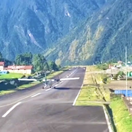
 |
| Askole - where few dare... |
There are places on this planet where time folds in on itself—where snow fields stretch like frozen oceans, where silence is not the absence of sound but the presence of something ancient. Snow Lake, deep in the heart of Pakistan’s Karakoram range, is one such place. Few attempt it. Fewer return unchanged.
I’ve walked among giants before—stood on the summit of Kilimanjaro, traced the ice rivers to K2 Base Camp, crossed the mighty Gondogoro-La, and breathed thin air at Everest Base Camp. But this—this was something else entirely. This was my third journey beyond Askole. And even then, Snow Lake had a mystery, a whisper, a call I couldn’t ignore.
Day Zero & Day One: The Fellowship Begins
Every great journey starts long before the first step. For us, it began with a flight to Skardu, that majestic mountain town nestled at the edge of the world. From there, a four-hour jeep ride—more like a test of nerves—took us toward Askole, the last inhabited outpost before the wilderness swallows you whole.
Once you cross that first twisted turn and the wildly suspended bridge over a raging, glacial river, the civilized world drops away. Something stirs within. Your soul, perhaps. Askole is more than a village—it’s a portal. Every glacier-bound dreamer begins here. You can see it in the faces of trekkers from across the world—some weathered, some wide-eyed, all chasing something intangible.
That night in Askole, under a canvas of stars and the roof of our tents, we met the people who would make our madness possible: the guides, porters, and cooks—unseen, unsung heroes of every Karakoram expedition. Giants in humility, strength, and grace.
And then there was us: myself, my friend Imad, the wonderfully wild Kevin—a Singaporean Canadian with a taste for chaos—and the two Ranas from Gujranwala, whose humor and grit kept the group grounded. We called ourselves the Fellowship of the Biafo—named after the glacier that would lead us to the mythical Snow Lake.
 |
| The fellowship |
The next morning, the hike began. Within half an hour, the landscape changed its skin. From sandy trails to treacherous moraine, where ice hides beneath shifting rocks, daring every step. The rhythm was relentless—up, down, slide, scramble, repeat. The glacier wastes no time testing your resolve.
After 7.5 hours of climbing, slipping, balancing, and cursing the moraine’s merciless undulations, we reached Namla—our first camp. Legs were sore, backs were aching, but eyes were wide with awe. We were in it now. No turning back.
Day 2: Ice, Cravasses, and the Most Beautiful Camp
The sun rose gently over Namla, casting golden streaks over the jagged edges of the Biafo Glacier. We were now fully committed to this journey, tracing the ancient white highway that would lead us to Hisper-La—the storied pass that links Skardu to Hunza. It’s not just a crossing; it’s a convergence of worlds, histories, and altitudes.
We started early, knowing we had another 7–8 hour day ahead. The first part was deceptively familiar—back on the moraine, dancing once more over loose rocks perched on hidden ice. It’s an odd thing, learning to trust your feet where no trail exists—just instinct and balance.
As the hours passed, something shifted. The glacier began to shed its camouflage. Rock gave way to shimmering white. We were now walking on visible ice—serrated, glassy, and alive. And with it came the first real encounters with the crevasses. Some narrow enough to leap across, others gaping and dark like the mouths of sleeping giants. We stepped carefully, our eyes scanning every footfall, every glint of sun off the fractured surface.
Midway, we stopped for lunch. And what a lunch spot it was—folding chairs and a small table set right on the glacier, snow-capped peaks surrounding us like a royal court. There was something oddly civil about eating a meal in that wild silence. The only sound: the crunch of ice under our boots, like the mountain breathing beneath us.
The second half of the hike was pure glacier. The sound of the crampons digging into ice—crunch, crunch, crunch—became almost meditative. It felt like the glacier was speaking to us in its own ancient rhythm: Come further. Come carefully. Come find what you came for.
Then came the final hour. Always the sting in the tail. The climb to Shafong tested whatever reserves we had left. But once we crested that last icy hump, it all made sense.
Shafong is, without question, one of the most breathtaking campsites I’ve ever laid eyes on. Surrounded by sheer beauty—snow walls on every side, silence so deep you can hear your own breath. We pitched our tents with awe more than effort. The evening light made the glacier blush, and as we sat with warm mugs in hand, a strange calm settled over us.
We weren’t just walking a path. We were stepping into a legend.
 |
| The crevasses start |
Days 3 & 4: Baintha — Stillness at 4000 Meters
After the grind of moraine and ice, Day 3 felt like a gift—a reprieve from the glacier’s endless undulations. The trek from Shafong to Baintha was short, barely an hour, but in these mountains, even the quiet days write their own epic.
Baintha is perched at 4000 meters, nestled on a green patch beside the glacier—a surreal burst of color in a world of white and stone. It’s a place where the body begins to notice the altitude, where breaths get shorter and thoughts turn inward. For most of us, this was the moment to start Diamox. For the mountains, it was just another day.
But Baintha gave us something even rarer than rest: perspective.
Shortly after we arrived, a thrum echoed across the ice—a distant, mechanical roar. Overhead, two Pakistan Army aviation helicopters thundered into view, weaving deftly between the ridges. A Dutch climber from one of the groups ahead had twisted her ankle badly and needed evacuation. It was swift, surgical, and deeply moving to witness. In that vast wilderness, the sight of a helicopter feels like something out of mythology. The sheer skill and courage of the pilots—navigating wind, ice, and thin air—reminded us that in these remote reaches, heroes often fly.
Later, I did something slightly less heroic—though certainly more foolish. I swam in a glacial lake at 4000 meters. It was numbingly cold, absurdly beautiful, and utterly unforgettable. As my limbs screamed and my heart pounded, I felt more alive than I had in months.
 |
| The pizza at 4000m |
Baintha is also where we met the others chasing this same frozen dream. A group of Spaniards, average age 65, their grit and laughter echoing through the camp like music. And a diverse Dutch-led group that included four remarkable Pakistani women from Karachi—trekking through terrain that most wouldn’t dare imagine.
In Baintha, there are no boundaries. No countries. No differences. Just people brought together by a shared madness for mountains. Conversations flow in a mix of English, Spanish, Dutch, Urdu—and yet, none of that really matters. Because the glacier has its own language, and we all learn to listen: the cracking of distant ice, the whisper of snowfields, the heartbeat of the earth.
These were the calm days, the easy ones. And we needed them—because beyond Baintha lay the raw heart of the Karakoram. The glacier would soon rise, steepen, and begin to test the soul.
But for now, we let ourselves breathe.
Day 5: Into the Ice Kingdom — Baintha to Marfogoro
After two days of stillness and altitude adjustment in Baintha, we woke on Day 5 with a strange mix of calm and anticipation. The body, though rested, now carried the weight of elevation. Every breath was a little shallower, every movement just a bit more deliberate. But spirits? They were soaring.
Perhaps it was the miracle of Pizza at 4000 meters—courtesy of our magician-cook Akbar—that gave us our energy. Or maybe the acclimatization hikes, short but sharp, that Nabi, our ever-composed guide, led us through the day before. But more than anything, it was nature’s blessing: not one, but two rainbows arcing across the Baintha sky, as if the glacier itself had raised flags to welcome us deeper into its icy heart.
This is where the expedition begins to feel otherworldly.
We were now stepping into the second-largest mass of ice outside the polar regions—an expanse of raw, white wilderness that feels like it belongs to another planet. There are no trails here, no footprints to follow. Only instinct, the crunch of your boots, and the trust in your guide’s eyes.
The trek to Marfogoro starts easily enough—straight onto the glacier, a broad path of crystalline ice stretching endlessly ahead. The horizon, impossibly far, is studded with peaks rising above 6000 meters, like frozen gods watching silently from above.
But beauty is never without its cost.
After a couple of smooth hours, the terrain begins to shift. The crevasses reappear—and this time, they’re deeper, more cunning, and far more frequent. Wide enough to swallow you whole, narrow enough to be missed with a single careless step. Here, ice is illusion. What looks firm may be hollow. What appears harmless may be hiding a chasm.
There are no ropes at this stage. Just your eyes, your boots, and your wits. The silence becomes sharper. Conversations taper off. Everyone watches every step.
The climb itself isn’t steep—but altitude, now nearing 4300 meters, adds weight to every motion. You feel it in your lungs, in your temples, in the thirst that just won’t go away. Water becomes your anchor. Hydrate, pause, breathe. Repeat.
After about five hours of careful navigation, we reached Marfogoro—a campsite flanked by ice ridges and secrets. It’s not the most scenic, but it feels like a gateway. A threshold between the glacier’s edge and its sacred core.
Tonight, the glacier sleeps beneath our feet. Tomorrow, we’ll walk deeper into its dreams.
 |
| Marfogoro - The red rock |
Day 6: Karfogoro — The Black Rock Before the White Kingdom
Every trek has a turning point. A place that feels less like a campsite and more like a watchtower. Day 6 took us to that edge—to Karfogoro, the final human refuge before the glacier opens into its most sacred, surreal form: Snow Lake.
We left Marfogoro in the familiar early light, glacier dust shimmering beneath our boots, the rhythm of the past few days now embedded in our legs. The trek today was about 5 to 6 hours—similar to the day before—but the terrain was beginning to feel... louder. Not in sound, but in symbolism.
Do you know that Marfogoro and Karfogoro are named after peaks that rise silently above them? “Marfo” means red, and “Karfo” means black. The Red Rock of Marfogoro watches the dreaming trekkers arrive—those still caught in the rush of blood and ambition. But Karfogoro, the Black Rock, is the guardian. It stands like a sentinel on the cliff's edge, the final threshold between reality and the snow-clad dream world ahead.
Standing there, I couldn’t help but think of Game of Thrones, of the long Wall and the vast lands beyond—untamed, unknown, and waiting.
Today, the crevasses turned more sinister. They were no longer easy-to-spot gaps or thin cracks—they were deep, monstrous chasms. Some we could jump. Others, we had to circle entirely. From a distance, they looked like simple shadows. But then you’d see Imad, walking on the far edge of one, looking like a toy figure next to the vertical drop. That’s when you realize: this glacier doesn’t play. It tests.
And yet, the beauty ahead was impossible to ignore. For the first time, the view ahead widened. Snow Lake was no longer a myth—it was just out of reach, its smooth white expanse beginning to reveal itself in flickers between ridges and shadows.
 |
| The campsite at Karfogoro |
At 4600 meters, everything is more intense. The light. The silence. The anticipation. You feel the air thinning, but your heartbeat quickening.
Karfogoro was not the most comfortable camp—but it was unforgettable. Perched on a ledge, surrounded by steep drops and glacier cliffs, it felt like a lookout post into another world. We knew: the next day, we would walk into Snow Lake. A place so few have seen that its name still stirs disbelief.
That night, we barely slept. The cold bit harder. The stars burned brighter. And the dream... felt close enough to touch.
Day 7: Crossing Snow Lake — Into the Heart of the White Wilderness
You don't just walk into Snow Lake. You cross into it with reverence.
We woke early at Karfogoro. This was the day—the day we would step into the legend. Our prayer that morning was longer. Words felt heavier. The stakes, higher. The Dutch were two days ahead of us, the Spaniards had left just an hour earlier, their footprints dotting the white canvas in faint trails. Their presence ahead would help us distinguish foothold from fall, stability from danger.
Despite their average age of 65, the Spaniards were showing a resilience that both inspired and humbled us. They planned to cross Hisper La today—an ambitious, grueling stretch. We, however, chose to savor. To linger. To camp in Snow Lake’s embrace for one night and breathe in this rarefied dream before the final push.
As we stepped onto the lake, the vastness swallowed us whole. The mountains, towering and proud, appeared so deceptively close. But then you’d squint, and you’d see tiny black dots—like ants—crawling across the surface. That’s when you realized: those were the Spaniards who left ahead. That’s the scale of this place. It breaks your sense of distance, of proportion, of self.
 |
| The sunrise at snowlake |
Snow Lake isn’t just a destination—it’s a test of trust. This was the first of two days on rope and harness. A slip here is not just a mistake—it can be catastrophe. It’s all for one and one for all now. Every crevasse is a question. Every snow bridge, a whispered dare.
But even more powerful than the danger was the sadness.
Our guide, Nabi, paused often, pointing out changes. He’s been coming here after a decade. Ten years ago, he says, you could walk a flat, football field-sized snowfields straight to Hisper La. The ice then was thick, defiant, eternal. Today, it moans underfoot—its agony echoing with every crack. We zigzag around wide-open wounds in the glacier, some too deep to see the bottom.
He fears the future. Fears that in a decade, there might not be any Snow Lake left. Just rocks, meltwater, and memories. This loss is not just visual—it’s existential. Because the water trapped in this white kingdom feeds life downstream. Every crack here is a threat to the green fields of Punjab and Sindh, to the rice farmers waiting for snowmelt, to the homes that depend on this ancient reservoir.
The butterfly effect in full force: a single block of melting ice in Snow Lake today might mean an empty plate for a family hundreds of miles away tomorrow.
Come now. Before it disappears. And when you return, carry its memory not as a trophy—but as a responsibility.
 |
| The sun sets at Hisper La base camp |
There’s a line in Jurassic World that I kept thinking of: “Nature always finds a way out.” Let’s not force her hand.
It took us just under four hours to reach the base of Hisper La—4,800 meters high and resting at the crossroads of glaciers that feel like long-lost friends meeting again. The view was endless: snow, sky, silence. This was our camp for the night.
And did I mention? This is one of the few treks on Earth where you walk on a glacier every single day. I didn’t know that before I came. But now I understand. This trek isn’t just about beauty—it’s about endurance. It keeps testing you till the very end.
 |
| The kingdom of ice and snow |
And if I thought I had seen beauty before—boy was I wrong.
If I thought the danger of crevasses was behind us—boy did I underestimate Hisper.
But that’s tomorrow’s story.
Day 8: Crossing Hisper La — A Walk of Faith from Skardu into Hunza
At 5,100 meters, between the skies of Skardu and the valleys of Hunza, lies a pass carved not just in snow and stone—but in memory.
We spent the night at the base of Hisper La in a place that defies words. Sunset cast an amber glow across the glacier, turning the ice into gold. Sunrise answered with streaks of fire painting the sky. But once the sun dipped behind the peaks, the cold came quickly—and cruelly. A churning wind swept in, and the night froze around us. This is not your average mountain chill—this is bone-deep cold. If you're ever here, know this: warm clothes and a high-quality sleeping bag are not luxuries. They’re your lifeline.
Morning began, once again, with prayer. Longer. Heavier. Necessary. Two hours into the day, we’d understand why.
 |
| Spot the Spaniards |
We tied into our ropes. The porters had already set out ahead. We’d casually harnessed up, even laughed a little, mistaking Hisper La’s apparent closeness as comfort. But distance is deceptive on snow. What looked near was in fact a two-hour grind—and even our porters, those tireless northern sherpas, had paused to rest before the ascent.
That was the first sign: this wasn’t going to be a casual day.
Hisper La, as it came into view, looked like a velvet quilt of white—an ancient passage used by travelers and traders between two distinct worlds. Here, people from the harsh, proud lands of Shigar and Khaplu once met their kin from the lush valleys of Hunza. And this wasn’t the only pass—others splinter from Snow Lake toward Wakhan, Chitral, and beyond. This was once the Silk Road of glaciers. You could feel the history beneath your feet.
 |
| Climbing Hisper-La |
Two hours of climbing later, we reached the top. And there it was: Snow Lake, stretching endlessly before us—a white ocean of silence and time. I stood there, breathless, not just from the altitude but from the sheer magnificence. Like Concordia. Like G-La. Like Kilimanjaro’s crater. You don’t want to leave these places. Because you don’t know if you’ll ever get to return.
 |
| To the edge and beyond |
But the sun was climbing. And in the mountains, sun means melt. Melt means risk.
We began our descent.
This side of Hisper La was steeper, sharper, and far more dangerous. Crevasses lay hidden beneath powder-soft snow. We followed the footprints of earlier groups, but snow is a trickster—it molds, it shifts. Their path led us straight to a gaping crevasse, easily 100 meters deep, with no visible crossing. Turning back meant a one-hour detour, and more unknowns. Worse still, the path forward sat on a sheer ledge, barely two feet wide, flanked by vertical drops.
 |
| The crevasse deepens |
The decision? Build a bridge.
The guides and the sardar of our porters rigged a makeshift 7-foot crossing using tent poles and metal bars. We hurled our backpacks across to lighten our load. Then a second safety rope was tied, held firm by two porters.
I was asked to go first—steady footing, they said. More likely, easy to convince. I took a breath, whispered a prayer, and stepped forward. Just three steps. A walk of faith.
Then came the slide—lowering myself slowly onto the narrow ledge, inching sideways without ever placing full weight in one spot. One wrong move, and… well. But I made it. Solid ground beneath me, cheers from the porters behind. We had crossed. We had lived the Snow Lake adventure—and now we had stories to tell.
But Hisper had one more gift to give.
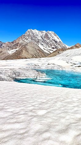 |
| The other side of Hisper |
As we descended further, the glacier unveiled something I can only call unearthly. I have never seen such colors in nature. Water so pure it shimmered turquoise. Ice wells so deep they could swallow skyscrapers. Glacial walls glowing white with streaks of sapphire, as if the mountains themselves had wept rivers of blue. Snow-capped peaks stood like guardians all around us.
 |
| Beauty beyond words |
It was as if we’d stepped into another world.
Eight hours later, we arrived at Khani Baysa—our camp for the night. We were tired. We were silent. And we were humbled.
 |
| The ice wells |
Caution for future trekkers: The cravasses on the Hunza side of Hisper La are more frequent and far deeper. If you come later in the season, when the snow softens, be very vigilant.
We slept that night not just as trekkers, but as witnesses. We had seen something eternal, and something fragile.
🎥 You can watch the video of our Cravasse crossing here:
https://www.youtube.com/watch?v=jaX_NnQ_wqg
It’s worth it. Trust me.
Day 9: Of Mountains, Mortality, and Moving On
Originally, we were meant to rest at Khani Byasa. After the drama of the crevasse, the cold of the pass, and the immensity of Hisper La, a day off seemed like the logical choice. But logic rarely survives in the mountains.
Snow Lake still lingered in our veins. The adrenaline of survival, the glow of achievement, and the beauty that wrapped around us like a second skin—it was impossible to sit still. Imad and I looked at each other over breakfast and knew: we were moving.
But this day would teach us a different lesson. A deeper one. A reminder that in these mountains, you don’t just find adventure—you find truth.
The Dutch group, who should’ve already left, were still at Khani. We soon learned why.
Among them was an old porter from Chilas, quiet and composed, whose steps had carved paths into these glaciers for decades. He had watched over Snow Lake for years. That morning, he had his last cup of Balti tea, said his farewells to his friends, and walked out—not to complete a trek, but to surrender to the call he had long felt.
He passed away peacefully that day, amongst the mountains he had served all his life.
They say he told his companions that he felt his time had come—and that when it did, he wanted to be here. Not in a hospital. Not in a city. Here—beneath the sky of Hisper, embraced by the silence of snow.
There’s now a marker for him on the trail. A metal plate, nailed into a wooden post, bearing his name. No grand stone, no tomb. Just a quiet reminder, resting where glacier meets earth.
I thought of a note I once saw at Angel Rock near K2 Base Camp, left by a wife for her husband:
“You promised to come home, but looks like the mountains loved you more than me, so you stayed.”
The porter stayed.
He is now the glacier. He is Snow Lake.
We moved forward with hearts heavy but souls humbled. The trail was expected to be a “light” four-hour day—our first steps back toward civilization.
But the Karakoram doesn’t let go so easily.
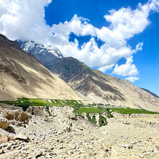
The trail from Khani Byasa to Khwari Shingal starts gentle, dancing over grassy moraine and open glacial pastures. Signs of life begin to emerge—traces of yak dung, patches of green, and a distant sense that people live somewhere nearby.
 |
| The halo and a look back at Hisper |
But then, the path turns. The moraines rise again. The trail becomes a test of ankle and will, hopping over boulders, tracing narrow cliffside paths cut quite literally by the daring of our porters. At times, there was no trail. Only instinct. And hope.
Streams began to crisscross our path—some peaceful, others angry with meltwater. We jumped. We slipped. We laughed. We cursed. But we moved forward.
 |
| The greens appear |
What was supposed to be four hours turned into seven grueling ones. Rock. Ice. Water. Repeat.
We finally reached Khwari Shingal, exhausted but intact. We were lower now but still wrapped in solitude. The terrain was changing—but not yet familiar.
Just three more days, we thought. A few more hours each. And we’d be in Hisper village.
But boy, were we wrong again.
Day 10: Cairns, Glacial Ice, and the Thin Line of Luck
By Day 10, you’d think we’d seen it all. And yet, the Karakoram continues to whisper secrets with every step—sometimes in silence, sometimes with a roar.
We began, as we always did, with breakfast under grey skies and cheerful banter. Talk of the trail ahead. Jokes. Guesses. That burst of morning optimism. And then—as always—gravity took over. Legs grew heavy, air grew still, and we once again found ourselves picking through a glacial jigsaw.
The Yutmaro Glacier greeted us next. A maze of ice, rock, lakes, and towering moraines. Across its shimmering surface, a solitary hill stood, like an island in a white sea. We could just make out glacial lakes shimmering in the distance, and what looked like another day of treacherous ups and downs. But this time, the air felt thicker, friendlier. We were descending now, and though the terrain was no less complex, it was no longer chokingly high. It was... familiar.
Our porters, ever the pathfinders, had gone ahead as usual. Their job, one we’d come to deeply respect, was to find safe passage through a constantly shifting landscape and mark it for us—using stone piles, cairns, or inuksuk, as I’d learned to call them during my time in Canada. Ancient symbols of guidance, direction, and survival.
Our guide Nabi walked with us today, his eyes reading the landscape like scripture. He pointed, marked mental maps, quietly signaling turns to remember.
 |
| The maze |
As we descended onto the glacier, caution returned. Moraines are never stable. A rock that looks like part of the mountain may be a moment away from giving way. So we zig-zagged, descending like mountain goats, always mindful not to dislodge stones onto those below.
Across the glacier, we could see the porters gathered at the base of the hill. Something was off. The standard trail, a gentle sloping path up the side, had been washed away by landslides. What they were now scouting looked almost vertical.
We didn’t think too hard about it. Because if you thought too much up here, you’d freeze. Better to just trust the guide, the path. And walk.
Then came one of those moments—the kind you never forget.
We encountered a wild overhang of glacial ice, perhaps 50–60 feet high, hanging like the frozen lip of a giant wave above a raging meltwater stream. Below it, water gushed and frothed, carving new paths with reckless abandon.
Nabi motioned: Go. Now. Quickly.
The wall
We didn’t argue. He knew the risk—these glacial arches can collapse without warning, and any falling ice or rock would mean disaster. We ran across, the water roaring beneath our boots. Kevin was just ahead of me, mid-jump across the narrow stream when the rock he’d stood on a second earlier slipped and crashed right where he’d been. One breath later, and it could have ended very differently.

The mountains had spoken again. Respect me. Or remember me.
As if to balance the moment’s intensity, rain began to fall gently, cooling the air and washing the slopes in a soft haze. The clouds dropped low, brushing the peaks like old friends. And then—out of the mist—our reward.
A herd of Yaks.
Silent, majestic, grazing against the dramatic backdrop of stone and snow. Watching us with that ancient calm that only mountain creatures seem to possess. We stood still for a while, soaked, tired, and utterly present.
By the time we reached Iskambri, we were soaked to the bone—but strangely grateful. Every part of today’s trek had demanded our focus, and in return, it had given us everything—drama, beauty, fear, humility.
What a day indeed.
Day 11: Beetanmal — The Luxury of Water, the Warmth of Goodbyes
We began Day 11 walking gently—yes, gently—on green slopes that rolled beneath our boots like a welcome mat from the valley. The snow was now only a memory on the peaks above. Their bases had softened into meadows, and the ground beneath us finally gave, without resistance, to each step.
After the stark white of Snow Lake, the glaciers of Hisper La, and the brutal beauty of the Karakoram, it felt like we’d stepped into a painting. A few short climbs reminded us we were still earning our miles, but they came with flowers blooming defiantly between rocks, sunlight that warmed rather than burned, and air that filled lungs instead of stealing breath.
Five hours later, we arrived at Beetanmal.
This wasn’t just a campsite. This was civilization—at least, by mountain standards. Toilets. Running water. A stream that ran laughingly through the center of camp. Our tents, pitched below 4000 meters now, were slowly being baked into saunas by the sun—but no one complained. The heat felt… earned.
We dipped into the stream like children. Washed our clothes, our faces, our fatigue. Shirts and socks were spread like prayer flags on our tents, fluttering dry in the alpine breeze. The sky was blue, the grass was green, and for once, there was nothing urgent to do.
Just be.
This was our last night on the trail. Tomorrow we would reach Hisper village—the final marker. After so many days of watching our breath crystallize in the air, tonight we pulled out the trekking sandals and stashed away the down jackets.
 |
| The meadows before Beetanmal |
We even had cake—baked somehow by our tireless kitchen crew, who had once again performed a small miracle at high altitude. We cut it with laughter and hugs, quietly acknowledging what we had shared, and what we would soon leave behind.
That night, as I lay inside a tent warmed by the day's sun, I found myself suspended between joy and longing.
Happy to have done it. Grateful beyond words.
But wishing, just a little, that it had lasted a bit longer.
Snow Lake wasn’t just a trek. It was a slow-burning dream—a walk through myth, into silence, over crevasses, beneath stars, beside strangers who became something more.
And tomorrow, it would be over.
Day 12: The Last Descent — From Snow Lake to Hisper
Twelve days.
One hundred and twenty-seven kilometers.
Five thousand one hundred meters above sea level.
And a lifetime’s worth of memories.
Day 12 began the way most others did—on green slopes brushed with morning calm. But this time, it felt different. The air was softer, the trail more forgiving. Yet with every gentle step, a quiet ache settled in: This was the end.
From Beetanmal, we traced a familiar rhythm—up and down, over moraines and ridges. The porters, as always, scouted ahead, cutting one final vertical line into the hillside, refusing to let us have an easy end. We cast one last glance behind us—toward the Hisper La, toward Snow Lake—knowing that part of us would forever remain there.
And then, just before the final stretch, the mountains gave us one last trial.
A glacial stream, swollen with meltwater, rushed across our path—thigh-deep and roaring. There was no avoiding it. We stepped in, the cold gripping our bones like a final embrace. It felt less like a crossing and more like a ritual—the glacier taking its final tax, clinging to us, as if to keep a piece of our soul.
Moments later, we reached the man-made bridge over the roaring Hisper River. It felt symbolic. A threshold. A crossing from the land of giants to the land of men.
On the other side, children from the village ran to greet us—barefoot, laughing, dancing up the steep slopes that were taking us every last ounce of energy to climb. They ran like the wind, like wildflowers in motion. And us? Middle-aged, sunburnt, half-broken—we followed, smiling, aching, and whole.
Six hours in, we reached Hisper Village. The trek was done.
 |
| Hisper Village |
We paused for an hour, rested under the shadow of apricot trees, and then, just like that, it was time to say goodbye. The jeeps were ready. The road to Karimabad—land of Rakaposhi—waited.
But first, we turned to our porters. The silent sentinels of the trail. The ones who carried not just our loads, but our dreams, our doubts, and our tents across the ice. When you thank them—and you must—do it generously. This is their livelihood. This is their life. And it is not an easy one.
Two hours later, we were back among paved roads, buildings, and hot food. Civilization, as it’s called.
But the mountains still loomed behind us—unchanged, unmoved, eternal.
They watched us go.
And now they wait.
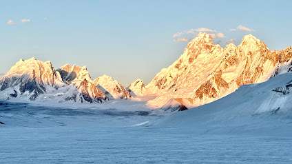
 |
| The Snowlake |
🌍 What Are You Waiting For?
You can witness the full journey here:
🎥 Snow Lake Trek: A Journey Beyond Askole
This was more than a trek—it was a passage through wonder, across silence, through stories etched in ice.
Let the mountains call you. Let them change you. But promise to return.
For Snow Lake doesn’t just visit your dreams.
It waits to welcome you back.